Manshan Spa Eco-Town

Sheling town planning consists of a Core Functional Area surrounded by 4 groups of communities with different focus: Science & Education Area, Business & Entertainment Area, Rural Leisure Area, and Waterfront Cultural Community.

Manshan Spa Eco-Town is located between the Waterfront Cultural Community and the Business & Entertainment Area, key development nodes for the region at this stage. The government intends to gradually extend the supporting infrastructure and facilities to build this area into a modern, attractive, and sustainable community for the future.

Hot spring facilities and holiday tourism make the core of the Spa Eco-Town. But with the integration of culture, entertainment, health, and sports facilities within an attractive and accessible landscape, it makes the proposal of a modern, complex and diversified town.

Ecological principles for balanced urban developing are upheld, with great emphasis on water management and connectivity. This attitude will be deepened by RhineScheme in the 1st Planning Phase, river landscape and hotel, at the very west end of the site.

The idyllic riverside sets the tone for RhineScheme’s proposal for a town dedicated to well-being. The landscape design for the riverside encourages community integration by the strategic inclusion of bridges and facilities, such as an aviary within a full-length network of side paths, optimized to develop and preserve wetlands and healthy waterways. The Waterfront becomes an axis of leisure, for both active enjoyment and mindful contemplation.  And with a wide array of possible activities for all seasons, it is also a valuable asset for tourism, making its conservation a business investment as well.

The more touristic part lies also on the west side of the development. In the center the hot springs and spa complex is designed for relaxation and comfort. A resort to the north and hotel to the south, offer various accommodation to adapt to different visitors’ preferences. And lastly, a lively touristic villa with shops, restaurants, and experience centers offers multiple entertainment options related to the place and connects to the riverside.

Surrounded by the residential areas, the geographical center of the Spa Eco-Town serves as the “Living Core” of the communities. Conveniently located in the intersection of the two main streets, big-scale service, business, and commercial centers are stablished here, along with the primary and middle schools that serve the whole town. The largest area of the proposal area is dedicated to housing. A great diversity of residential patterns is accommodated and combined, to suit different possible tenants and promote high-quality everyday life. Small-scale proximity commercial, sport, healthcare, and educational facilities are integrated in the different areas and interconnected trough continuous slow systems of biking, running, and walking paths that promote a healthier, more active, and more sustainable lifestyle.

A holistic health care center as well as a Chinese medicine hospital are marking the end of the town to the East. Similar to the spa and hot springs area, the health-focused planning is sparser and designed for relaxation and comfort. Elderly housing and a care home are also part of the area.

RhineScheme’s comprehensive approach to Zhongyi’s Sheling Town development in Changchun, proposes an eco-conscious, dynamic, and diversified environment for visitors and residents to invest in their well-being.

The close commuting with nature, slow-pace dynamics, and varied entertainment and wellness facilities make Manshan Spa Eco-Town an ideal place to enjoy a healthy, joyful and sustainable lifestyle.

Sino-German Eco-City Tianjin

Sino-German Tianjin Daqiuzhuang Eco-city (the “Sino-German Eco-city” for short) is located at the junction of Tianjin and southern farming area, bounded by Duliu Flood Relief Channel. Along the river originating in Xiongan, there are several reservoirs adjacent to each other. Neighboring to Tuanpohu Wetland Reserve, the Sino-German Eco-city has a very good ecological environment.

Integrating with the industrial status and ecological base of Daqiuzhuang, based on the “Sino-German Ecologic Model City” cooperation project, we seized the opportunity of German Industry 4.0, took the advantages of geography, drew lessons from Xiong’an New Area’s planning concept, adhered to international standards, and created a superior plan with Tianjin characteristics. It is hoped that Sino-German Tianjin Daqiuzhuang Eco-city is built into an eco-friendly city, a smart city, a modern city and a livable city.

We strengthened the base aggregation effect, and planned a continuous ecological open space to form a compound space from culture to ecology and from city to nature. The planning adopts the spatial structure of “one axis, one center, two corridors and three parks”. “One axis” is the central urban development axis, running through the whole Sino-German Eco-city, and connecting the urban administrative center in the east and the natural ecological landscape area in the west. “One center”, combined with the central water system, is built into the urban living room as the urban public center; “Two corridors” are the industrial revitalization corridor built on the basis of Baiyi Street and the ecological expansion corridor based on the new water system. “Four areas” include Corporate Headquarters Park, Sino-German Cultural Park, Baiyi Street Enterprise Incubation Park and four livable communities.

Wuhan Smart City & Eco City

Amidst a varied range of water bodies, the Smart City accompanies the Yangtze River bank, whereas the Eco City is located between the inner Dongjing River and Phoenix Road, a major city road leading to downtown Wuhan.

About ¾ of the overall planning area (84.7 km²) is made of abundant natural landscapes surrounding the two cities, composed of mountains, rivers, flood lands and artificial water ponds.

According to RhineScheme’s urban planning concept, both new towns are divided into themed districts with corresponding land uses. Within a coherent overall design, each of the districts receives its own architectural identity and individual urban structure based on its land use and theme. This is achieved through carefully knitting together the urban structure with the existing landscape and infrastructure, and by selecting appropriate architectural typologies and styles.

Smart City: Features

A new city district is going to be created in which advanced facilities and modern technologies provide energy-efficiency, environmental sustainability and – last not least – highest liveability.

The site-related official planning document “Smart City – Analysis of Development Ideas” has been setting up important basic guidelines to be followed, namely:

  • Low-density, low F.A.R.
  • Taking advantage of natural landscape resources to highlight the regional culture features of the area
  • To realize the characteristics of “smart city” initially, connecting public city resources (water, power, oil, gas, mobility and public services) and to monitor, analyze and integrate various data in order to create intelligent living standards.

In general, the concept of ‘SMART City’ has been introduced as a strategic device to highlight the growing importance of social and environmental capital within a framework of Information and Communication Technologies, in profiling the competitiveness of cities.

In particular, a city can be defined ‘SMART’ when investments in human and social capital, traditional transport and modern communication infrastructure fuel sustainable economic development and a high quality of life, with a wise management of natural resources.

The philosophy of RhineScheme’s proposal is based on the existing landscape as a foundation principle. Eight objectives have been identified and defined as follows:

  1. Create new spatial experiences and new fruitions founded on the idea of natural landscape and urban landscape.
  2. Facilitate the communication between people and nature.
  3. Set up a new model of economic district that relies on knowledge, tourism and education besides business.
  4. Propose a new traffic model that combines fast mobility with slow mobility.
  5. Define a new multifunctional ‘micro-centre’ that enables a lifestyle combining culture and education, living, working, leisure and sports at the same time.
  6. Create an urban space at human scale, rich of publicly accessible spaces and urban landmarks.
  7. Enhance the residents’/users’ feeling of identity and belonging to their place.
  8. Propose a new urban model for sustainable energy production and consumption.

The predefined road network is connecting the North-Western wetlands and the Eco City to the Yangtze River in the South-East, crossing the Smart City. An essential and necessary consideration has been to create a new Green Corridor following the roads infrastructure and connecting the wetland system with the Yangtze River basin.

This Green Corridor is at the same time an environmental connection, sustaining biodiversity and ecological flows, and an infrastructural channel that reorganizes the main public systems: water drainage, public transportation, auto mobility, etc.


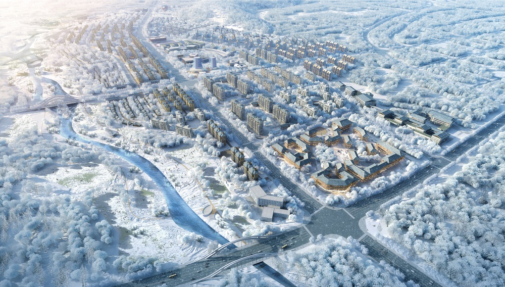
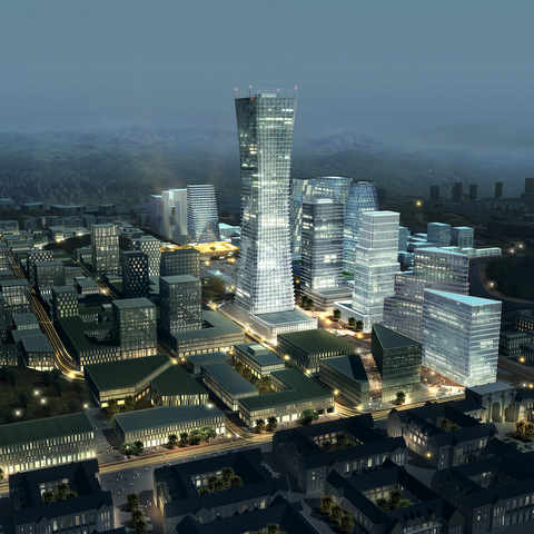
Smart City is divided into 8 districts interconnected by a network of regional highways and major roads. These districts respond to the major connections with a protective wall of higher buildings both shielding the inner areas and creating an urban atmosphere along the roads.

Towards the extensive water landscape and the Yangtze River front, the urban structure becomes dispersed and natural. The height of the buildings is reduced to minimize the visual impact on the landscape and to create a suburban appearance.

From a functional aspect, the Smart City consists of administrative areas, a commercial core, some R&D areas housing innovative industries which are synonymous for the district, as well as some high-level housing areas.
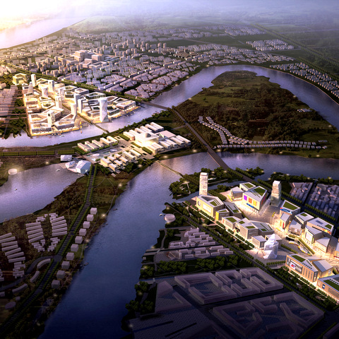
Eco City

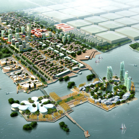
The Eco City consists mainly of residential areas with close connection to natural green areas.

It is settled between an industrial district in the north and the winding waterscape of Dongjing River. Most of the public and commercial facilities are oriented towards Phoenix Road in order to provide a strong spine and main artery. Towards the river the building heights decrease, and the urban structure becomes less dense and plays with the existing boundaries of water and land.

Strategically placed at the heart of the urban tissue, the Eco city core defines a town center and will provide services for the surrounding residential areas. It will include the administrative headquarters of the Eco City and various public use functions such as cultural, hospitality and commercial facilities.

Smart City: Core Area

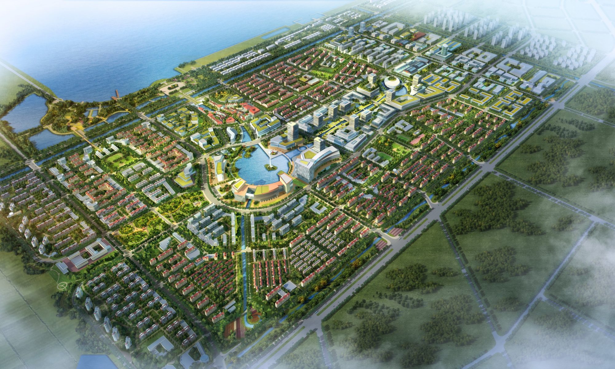
 The design for the Smart City’s core area aims for an urban scale which is restrained in size and density; water and irrigation canals as structuring elements have been kept and re-used as landscape features for retail, working or living areas.

The district planning was deepened for an area of 4.78 km² strategically located to take maximum advantage of the most attractive features of the territory: On one hand it is surrounding an existing lake, offering a quiet and relaxed atmosphere, ideal for reconciliation with nature and for a realm of slowing-down. On the other hand it stretches towards the Yangtze River, showing a denser and taller built environment able to serve as business card of the whole development. These apparently opposing functions are bound together by a Green Corridor running west to east, the ecological backbone of the Smart City and its main landscape feature.

Key method and strategy was to re-use the existing land structure to a maximum, which follows a complex geometry of canals and water ponds, in order to minimize disruptions and to make the planning efficient in terms of time, subdivision of land, and construction costs.

Main roads are therefore located on top of current banks dividing water ponds; existing canals are kept, improved and becoming elements of the landscape design; lower land areas of existing water ponds will become sunken courtyards or parking garages or other underground facilities, by that saving excavation costs.

Moreover, the existing water system becomes the distinctive structure of the overall development, with intended reference and similarity to ancient Chinese water towns. Existing water ponds are re-used and revived in order to create a unique and contemporary waterscape, dedicated to people and leisure.

A Water Park is created around an existing lake, with a new and unique water experience, taking advantage of the existing water ponds, water streams and the prevailing topography. A new urban experience will emerge based on the found structure of ponds and canals, with urban surroundings facing the new water axis and benefitting from unique and inspiring landscape resources.

Finally, a rich network of pedestrian connections and public transportation is designed around and across the whole area to facilitate an alternative mobility to replace or reduce private car traffic.

Smart City Core: Quarters

 Different functional quarters have been shaped with unique character and distinct identity. They define the character and living features of the Smart City Core, as there are:

The Water Park / Smart Living / Public Service Area / Shopping Water Town & SOHO / Living & Working Water Town / The Green Corridor / The Yangtze Waterfront / Urban Mansions along the Canal / Residential SOHO.

The start-up area measuring 1.65 km² and located around Chanjiang Lake will host the planning headquarters from which the city generates and also the first constructed area that will attract investors and future citizens. Both official and representative projects are placed here: The ‘Smart City Enterprise Centre’ will provide the necessary logistic support, while the ‘Smart City Exhibition Centre’ will host exhibitions and all kinds of information related to the planned city. A broader introduction to the envisioned cityscape will be given by samples of high-standard apartments and commercial areas that will be built there.

A cultural area is shaped on the south-west side of the lake, where a set of low-rise buildings, all with public functions such as museum and concert hall, will be integrated into the park’s landscape design.

The very center is shaped by a low-rise shopping area, which will take advantage of existing water and canals to create a human-scale environment with car-free areas dedicated to leisure, restaurants and meeting places.

Close to the highway crossing the plot in north-south direction, a modern SOHO development will show vibrant, dynamic facades to the cars passing by, benefitting from its good visibility.

On the east side of the plot, the skyline will gradually rise both in height and density. Finally, by the river bank, a group of landscape office towers will create an image of modernity and efficiency, carefully balancing between the low scale of the smart city and the size required by the wide Yangtze river which they are facing and from which they will be seen.

Yantai International Korean Town

The main traffic connections from East to West divide the site into three parts. The natural resources of sea, river, mountain and forest interconnect in the site and constitute its most valuable asset. These factors determine the main development direction: from sea and riverside towards the interior.

As reference, we can see that typical harbour/estuary cities base their growth on their history or on the industries which give the city its character. Our site is based on natural resources, which are new and pristine. So how does one define the new city’s character? How can a nice environment be integrated with the new city functions?

River, sea, forest and mountain. These elements help define the functional distribution and desired atmosphere: Proximity to the water determines the active, leisure and entertainment pole. Proximity to the forest park determines the more quiet, calm and private area for residences. Water and forest are brought into the site in a dramatic way to increase direct contact with the waterfront and the park, for better commercial performance, but at the same time of course with the aim of creating perfect conditions for a life-and-work balance.

Following this analysis, some key concepts for the new city’s main characteristics have been defined:

  • Korean culture in a Chinese-Korean Town will create a unique atmosphere based on eastern cultures. Firstly, the local culture is an attraction for non-Koreans, Chinese and foreigners who bring business and commerce. The good atmosphere will attract more tourists and business opportunities. Secondly, Korean City culture is an attraction for Koreans, an incentive for settlement and investment. The increasing visitor flow promotes business cooperation between China and Korea.
  • Tourism: All-season all-day tourism, suitable for various age-groups, multiple categories, one-stop service, multi-culture tourism.
  • Green construction / new energy resources: Wind, solar, and tidal energy, water treatment, central infrastructure corridor, low-carbon buildings, waste management system, slow urban transportation.
  • Self-sustainable / self-supporting: Meeting the demands of the physical and spiritual life of citizens. Containing a full range of industries and services to promote the development of the city without using the surrounding cities’ functions, at the same time pushing the development of the surrounding areas
  • Smart city: Using IT for the people to satisfy their need for food, clothing, living, transportation, sports, entertainment and various aspects of ubiquitous convenience. To foster the development of Chinese IT industry emerging application technology, strengthen the industrial advantage and national competitiveness.
  • Sea, Mountain, Forest and Estuary converge in a common zone of interest. A green loop is born, extended, and multiple loops appear on focal points. The existing road plan and its green protection areas form the base for the urban fabric. Main and secondary circulation nodes appear and integrate the existing towns as urban heritage areas. A riverside green public space loop is priority and forms the main landscape element. A secondary public green loop gives structure as an urban corridor connecting all areas.

Four main development poles have been defined, with specific functions – tourism, mixed use, science & technology as well as finance – that give structure to the zoning plan.
The development is divided into 5 stages. The first stage (which has been deepened carefully in RhineScheme’s design) is to become the heart of the city.

Due to serious political differences between China and Korea in 2017, the project has come to an unexpected complete stop.

Tianjin Sino-Singapore Eco City

Backbone and main identifying element of Tianjin Eco City is the so-called “Eco-Valley”.
Below this continuous green corridor of 12 km length, a new subway line will connect the districts and the centre of this new city for 350.000 people.
The figure of the Eco-Valley in its general shape is defined by its scenic situation near the river, following the curve of the old Ji canal, as well as by the interpretation of this situation by the master plan.
The double intersection of the Eco-Valley and the canal forms a natural inner core with a unique character. The isthmus area which is formed between the two water courses is reserved for research, conferences and exhibitions. In its north and south two areas of contrasting character are located.
The urban structure of this central bone differs in scale and shape from the surrounding urban texture. The core area is set off from the surrounding corpus of the city by clearly defined building flights and a surrounding green cordon.

King Abdullah Island

Through its nature and the type and scale of the proposed activities, PT is a unique development project on both kingdom and Arabian Gulf levels.
To achieve its objectives, PT aims to be a major IT hub and offshore R&D and financial centre in the area. Moreover, it includes two major infrastructure components:

King Abdullah’s Bridge (with 11 km length) will connect King Abdullah’s Road in Dammam with Riyadh Road on the adjacent Tarut Island, thus formulating a ring road around the built-up area. This measure will finally improve the accessibility and connectivity between the different parts of the study area. It is planned to extend this bridge for another 14 km to Ras Tanura in the second stage of the project.
King Abdullah’s Passenger Port will improve the connectivity of Dammam with major urban centres on the Arabian Gulf and act as a peer to Jeddah Port in the Western area of the Kingdom. It is planned for 1.5 million passengers per year in its first stage and to be connected to South-East Asia, mainly India and Pakistan, in the second stage.

Wenzhou Taishun Movie Town

Major target of the concept is the movie industry in a comprehensive functional chain, i.e. from the shooting to the public release of a movie, integrating to some extent tourism and real estate development. A mix of film-shooting, movie tourism, event culture, leisure and entertainment as well as high-end wellness and vacation is the aim. Eventually, the project will create a real new town in the region, for a more or less permanent population of at least 40,000 inhabitants.

The Central Area of the movie town is the pivot of the entire project operation and development. It is the dense and busy focus, with starred hotels and serviced apartments, with commercial and entertainment streets and – above all – a themed plaza in its middle with a fascinating amalgam of facilities for public events, as unique and memorable landmark. Moreover the Central Area provides commercial trading and operation for up- and downstream industries of the movie production chain.

4 themed development areas encircling the Central Area serve as carrier of movie culture and tourism: Coming from the ‘Tourist Service Center’ as initial point, visitors will firstly explore the European-style ‘Western Movie Town’ starting with a typical European square and special features of Western architecture. Further in the east, the new Film University for about 7,000 students will serve for education and for film-shooting as well.

The ‘Republican Theme Movie Town’ will create an image of the early days of the Republic of China during the 1920s and 1930s, in historical settings of mainly Old Shanghai and Guangzhou.

The ‘Ming/Qing Theme Movie Town’ will focus on the architectural and street style of Ming and Qing dynasties, including Chinese classical gardens. Finally the ‘Song Theme Movie Town’ takes its inspiration from the famous painting of a ‘Riverside Scene of Pure Brightness’, making water become its main subject.

Each area combines film-shooting and tourism, with separate entrances and without disrupting each other. Each provides a ‘one-stop’ functional area for movie production, including conventional studios and open areas for mass-scene shooting. The shooting locations are sensitively integrated into the existing landscape and old-established villages.

The concentric arrangement of the urban structure is a direct result of the development strategy: Like the pieces of a cake, every construction stage should comprise a part of the commercial areas in the centre, a part of the encircling movie towns and a part of other investments.

Caofeidian Eco City

A sequence of plazas and a series of 60-100m tall towers make the backbone clearly visible from afar. The promenade contains several ecological stepping-stones for recreation and storm water retention.

These urban pocket parks provide a niche for residents as well as for flora and fauna in the urban setting and help balancing the local climate.

Starting from this central area, the density decreases in direction to the canals in the east and west. The closed blocks with commercial and SOHO functions transform into more open residential patterns of smaller scale.

Parks with a natural shoreline and high biodiversity along the canals create a comfortable environment for the adjacent residential areas. Paths along the riverbanks, platforms reaching into the water and thematic gardens invite to recreational activities.

 To the south, the pedestrian promenade forks to the South Bank Park in one direction, and to the Sunrise Plaza of the eastern districts in the other direction.

The South Bank Park is a sheltered leisure beach park for residents and visitors. The park is lowered and has a protected water-body, which people can use for recreation such as kayaking. The south shore with its extensive natural areas can also accommodate cleansing biotopes to provide an excellent water quality within the so-called inner harbor basin.

Sport fields and lawns as well as a water stage add additional room for leisure.

The southern waterfront is set on a car-free island. Here piers, jetties and seating steps to the water and restaurants, hotels, commerce and leisure activities create a vibrant and maritime atmosphere.

The use of renewable energies, storm water management, priority for pedestrians and cyclists, efficient public transport systems, smart parking solutions and a car-reduced or car-free environment wherever possible are amongst the sustainable city objectives that will be implemented with the realization of this eco-water-city.

Shenxi New Town Centre

The growth of herbs in the nearby Changbai Mountain range has always played an important role in the wider Benxi region’s history. Provided that Shenxi New Town will become a dense business and administrative centre, the urban design approach has been guided by the development of natural features that already exist on the site. Keeping the environment balanced and sound is a key strategy, since it is nature – home to herbal plants – that provides the reason for implementing the urban design.

Especially the water courses flowing down from the surrounding mountains can enhance a strong connection between cityscape and landscape. Green corridors accompany the rivers and – as they come closer to the new town center – transform into landscape parks on both sides of the rivers.
These parks help keeping the urban fabric on a distance. Set back from the river bed, they give space for relaxation, recreation, but also to environmentally friendly pedestrian and bicycle use.
In the landscape concept, the Northern Riverbank assumes characteristics of an urban waterfront. It is marked by a pedestrian path made of colourful tiles which provide a pleasant spot throughout the year, where in Shenxis’ harsh winters flowers wouldn’t have ease to grow. Sharp edges and a range of features for pedestrians – platforms, pathways, ramps and stairs – put it in contrast to the Southern Riverbank Park, which is kept more naturally.

The urban fabric approaches the riverside parks in layers of different functions. Moving northwards, the layers increase in density. The 1st layer combines cultural and entertainment functions. Cultural buildings are aligned like pearls on a string, giving identity to thematic squares in their front: Museum of History, Technique & Science, Planning & Art Gallery, Library and Theatre/CPPCC Building (for political and for theatre & music performances) mark the principal cultural institutions within the New Town. These 4 cultural buildings merge into a belt of entertainment and shopping facilities, spots of health and wellbeing, restaurants and cafés.

The 1st layer lives from detached buildings granting a close connection between built and non-built environment.
The 2nd layer is composed of U-shaped mixed-use buildings opening up to the parks and a following row of courtyard buildings with a pedestrian zone in-between.
The following 3rd layer of high-rises is hosting representative offices; the urban structure culminates in a Business Square surrounded by four particularly shaped office towers.
The gradual increase of building heights towards north guarantees that most of the buildings benefit from a good sunlight exposure and from either their visual or physical connection to the green.
The 4th and last layer accommodates a mixed use of offices, service apartments and commercial & education facilities. This layer decreases in density and height and shall connect the urban fabric with its hinterland. It provides more differentiated open spaces of smaller scale.

At Theatre Square, the east-west running axis intersects with the north-south axis, which starts at Business Square in the north and ends in the round-shaped Governmental Plaza in the south.
The Governmental & Administration Complex occupies the most privileged location: on an exposed piece of land at the confluence of two rivers. It is embedded in a green surrounding which integrates it into an overlaying park, but also isolates the cluster from the rest of the town. A number of buildings are unified under a circular-shaped roof which makes the complex dominate rather by shape than by height. While the municipal functions are spread over a series of buildings, the governmental administration is located in a landmark tower at the edge of the circular shape. The buildings embrace a plaza for celebrations which gets access from north through a gate and opens towards the park in the south.

Zhangjiawo New Town

The compact core area of the town and planned city centre caters to trade and service sectors and is located in a south-eastern direction. It will be connected with the cultural centre of the town by a pedestrian passage running above street level.
The first residential developments have already been built.
The central area combines a traffic hub with HSR, bus, subway (planned MTR line no.3) and tram stations as main booster of the development with shopping malls, cultural areas, mixed use and living areas, as well as diverse service areas.

A ring-shaped green belt with watercourse defines the borders of the core area – similar to the demolished city walls around a medieval European town – and at the same time creates the necessary distance between town centre and surrounding express ways.